Nepal-Tibet Flood Mystery: Satellite Images Point to Massive Glacier Collapse
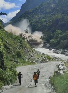
Glaciers scientists are pointing out to sharp rise in temperature in glacier areas in Tibet behind Nepal flash floods. (Image video grab)
By TRH World Desk
A 2026 study finds glacier loss in Nepal’s Langtang Catchment has accelerated more than fourfold, while high-altitude warming and glacier fragmentation are increasing geohazard risks.
New Delhi, August 27, 2026 — New satellite analysis suggests a massive glacier collapse and ice-rock avalanche, rather than a conventional glacial lake outburst flood, triggered the catastrophic flooding along the Nepal-Tibet border on August 26.
New satellite analysis is pointing to a massive glacier collapse and ice-rock avalanche as the likely trigger for the catastrophic flood that struck the Nepal-Tibet border region, shifting the focus away from initial speculation that the disaster was primarily a glacial lake outburst flood (GLOF).
The event has renewed concerns about the growing risks posed by rapidly changing high-mountain environments as glaciers across the Himalayas lose mass, thin and become increasingly fragmented.
Climate and weather specialist Jeff Berardelli, chief meteorologist and climate specialist, said temperatures in the area of the glacier collapse have been rising at roughly twice the average global warming rate. He said the local warming amounts to about 5°F since 1940.
Berardelli cautioned that further investigation is needed before establishing a direct link between warming and the specific collapse. But he said the broader evidence is clear: glaciers around the world are becoming less stable.
Glacier loss accelerating in Nepal Himalaya
A newly published 2026 study of glacier change in Nepal’s Langtang Catchment provides important context.
The study, published in Global and Planetary Change, found that the Langtang Catchment lost about 41.5% of its glacier area since the Little Ice Age, equivalent to approximately 78.5 square kilometres. At the same time, the number of glaciers nearly doubled from 58 to 115, largely because larger glaciers fragmented and became disconnected.
More significantly, the researchers found that the rate of glacier-area loss increased more than fourfold.
The rate rose from about 0.11% a year during the period from the Little Ice Age to 1964 to 0.49% a year between 1964 and 2023. The rate accelerated further after 2000, reaching approximately 0.79% a year during 2000-2016 before remaining around 0.5% a year during 2016-2023.
The researchers also found pronounced elevation-dependent warming. Above 4,000 metres, warming was approximately 0.3°C per decade, compared with about 0.1°C per decade at 3,865 metres between 1964 and 2023.
The study identified glacier thinning, declining flow velocities and rising equilibrium-line altitudes as important features of the ongoing transformation. Rising equilibrium-line altitudes are increasingly intersecting with thin, steep and heavily crevassed icefall zones, contributing to fragmentation and disconnection.
“The Flood Is Unprecedented and Huge”: Nepal Scrambles as Bhotekoshi Flash Flood Devastates Rasuwa
What triggered the Nepal-Tibet disaster?
The precise chain of events behind Wednesday’s disaster remains under investigation.
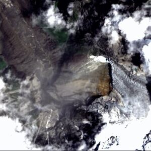
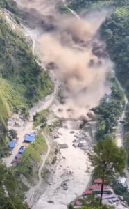
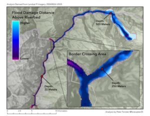
Initial reports suggested that a glacial lake outburst flood could have been responsible. However, satellite imagery has subsequently indicated that a large mass of glacier ice, rock and sediment collapsed from a high-altitude slope and entered the river system.
Geohazard researcher Dave Petley, writing on the Landslide Blog, reported that satellite imagery had identified the location of the initiating collapse and said the disaster was triggered by the collapse of a glacier high in the mountains.
Other preliminary analyses have similarly pointed toward a glacier collapse and subsequent ice-rock avalanche. One analysis placed the source at an elevation of around 5,200 metres, where a section of glacier appears to have broken away and dropped more than a kilometre toward the valley below.
A GLOF contribution has not been completely ruled out. The eventual disaster may have involved a cascading sequence in which glacier collapse, rock and ice debris, river blockage and sudden release of water combined to produce the devastating flood surge.
A warning for the wider Himalaya
The significance of the disaster extends well beyond the immediate flood zone.
Glaciers do not have to disappear completely to become a serious hazard. Thinning, fragmentation, loss of structural support and the development of unstable icefalls can alter the way high-altitude slopes behave.
The Langtang study warns that with continued warming at high elevations, fragmentation and disconnection could become increasingly dominant modes of glacier recession, with consequences for regional hydrology and glacier-related geohazards.
That makes the Nepal-Tibet disaster an important case study in the emerging era of compound mountain hazards — where glacier retreat, unstable slopes, avalanches, river blockages and sudden floods can interact.
For scientists, the immediate priority will be to reconstruct the sequence of the August 26 event using satellite imagery, seismic records, terrain data and hydrological observations.
For communities living downstream of Himalayan glaciers, however, the incident offers a more immediate warning: a warming high-mountain environment can change not only how much water glaciers release, but also how safely the mountains hold ice and rock.
The 2026 Langtang research, meanwhile, underscores that this transformation is not occurring in isolation. Glacier area loss has accelerated sharply over the past six decades, while thinning and fragmentation are increasingly reshaping the Himalayan cryosphere.
The Roof of the World Is Melting — And Downstream Nations Are Running Out of Time to Prepare
Follow The Raisina Hills on WhatsApp, Instagram, YouTube, Facebook, and LinkedIn




About The Author