Nepal Flood Disaster: What Planet Satellite Images Reveal About the Trigger
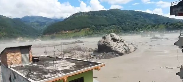
A massive boulder is swept through in the Nepal flash flood (Image video grab)
By TRH World Desk
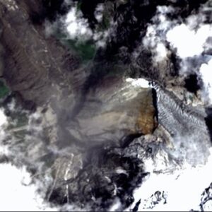
Planet’s August 26 satellite data show the Bhote Koshi–Trishuli disaster corridor before and after the flood, with a preliminary assessment pointing to an ice and rock avalanche from a glacier.
New Delhi, August 27, 2026 —Planet satellite imagery of the August 26 disaster along the Bhote Koshi–Trishuli river corridor provides preliminary evidence that an ice and rock avalanche from a glacier in the upper catchment triggered the devastating outburst flood.
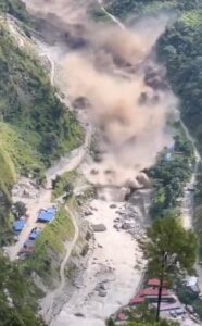
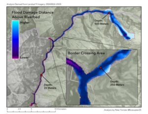
The catastrophic flood that swept through the Bhote Koshi–Trishuli river corridor along the Nepal-China border on August 26 appears to have been triggered by an ice and rock avalanche from a glacier in the upper catchment, according to the preliminary expert assessment accompanying satellite data released through Source Cooperative.
The disaster killed at least 160 people and left hundreds missing, including tourists and workers, according to the Planet Crisis Response data release. Nepal Police reported at least 157 deaths, while Chinese state media reported three deaths and 265 people missing in Gyirong County in the Tibet Autonomous Region. The casualty figures were described as provisional and were still rising at the time of the data release.
The Planet dataset is particularly significant because it provides satellite imagery from before and immediately after the disaster, allowing the affected river corridor to be examined through a common geospatial record.
“The Flood Is Unprecedented and Huge”: Nepal Scrambles as Bhotekoshi Flash Flood Devastates Rasuwa
Satellite imagery captures the disaster corridor
The Planet Crisis Response release contains 14 PlanetScope satellite scenes divided into two collections: five pre-event scenes acquired on May 27 and nine post-event scenes acquired on August 26. The imagery has a ground sampling distance of roughly 3.8 metres.
The pre-event imagery covers a north-south corridor beginning at Trishuli Bazaar (Bidur) and extending through Betrawati, Dhunche and Syabrubesi to the Rasuwagadhi border crossing, continuing into Gyirong County in Tibet.
The imagery was acquired about three months before the flood, at the end of the dry season.
The post-event imagery was captured on the morning of August 26, with two adjacent satellite swaths acquired at 05:01 UTC and 05:45 UTC. Together, they cover a wider corridor extending toward the Langtang valley.
This before-and-after coverage gives researchers a valuable record of the landscape surrounding the disaster, although the data also come with important limitations.
Planet cautions that the post-event imagery was collected during the Nepal Himalaya’s monsoon season and is affected by severe cloud cover.
Cloud cover in the post-event scenes ranges from 62% to 93%, leaving only about 2% to 14% of each scene clear. Planet says most post-event scenes show cloud tops rather than the ground, meaning usable imagery varies substantially from scene to scene.
Two of the least-obscured post-event scenes had clear fractions of 14% and 11%, respectively.
That limitation is important when interpreting the imagery. The satellite data provide evidence about the disaster corridor and its changes, but they should not be treated as a complete unobstructed picture of the affected terrain.
The Roof of the World Is Melting — And Downstream Nations Are Running Out of Time to Prepare
Why the glacier avalanche assessment matters
The preliminary expert assessment accompanying the dataset attributes the flood’s trigger to an ice and rock avalanche originating from a glacier in the upper catchment. However, the release explicitly says that the cause remains under investigation.
The available data establish a preliminary assessment rather than a final scientific reconstruction of the event. The disaster’s precise chain of events will require further investigation of the satellite imagery, terrain and other available evidence.
The Planet release itself therefore avoids presenting the glacier avalanche explanation as a definitive final conclusion.
The dataset also illustrates the value of commercial satellite imagery during sudden disasters.
The post-event scenes were acquired only hours after the August 26 event, at 05:01 and 05:45 UTC. The imagery therefore provides a near-real-time remote-sensing record of the affected corridor.
The pre-event data use surface-reflectance processing, while the post-event data available when the catalogue was assembled used top-of-atmosphere radiance. Planet specifically advises against directly differencing the two analytical products without atmospheric correction. Their visual assets, however, are directly comparable.
The Source Cooperative release establishes several key facts about the event and the available satellite record.
The August 26 disaster occurred along the Bhote Koshi–Trishuli river corridor, crossing the Nepal-China border. Planet has made available pre-event and post-event satellite imagery covering the region. The preliminary expert assessment identifies an ice and rock avalanche from a glacier in the upper catchment as the likely trigger.
The strongest conclusion from the data is that the disaster warrants further examination as a glacier-related outburst flood event potentially triggered by an ice-rock avalanche, rather than assuming a definitive mechanism before the investigation is complete.
Nepal-Tibet Flood Mystery: Satellite Images Point to Massive Glacier Collapse
Follow The Raisina Hills on WhatsApp, Instagram, YouTube, Facebook, and LinkedIn




About The Author