Nepal Floods: Was a Massive Glacier Collapse Behind the Deadly Debris Flood?
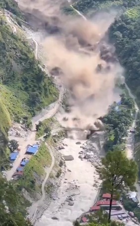
Nepal Floods: Glacier Collapse May Have Triggered Lhende-Bhotekoshi-Trishuli Debris Floods, says an expert. (Image video grab)
By TRH News Desk
Geographer Dr Vaibhav Kaul says a massive ice avalanche from the Langtang Lirung massif may have transformed into a devastating debris flow along Nepal’s Lhende-Bhotekoshi-Trishuli river system.
New Delhi, August 27, 2026 — The devastating floods that swept through Nepal’s Lhende-Bhotekoshi-Trishuli river system on August 26 may have been triggered by a massive glacier collapse and ice avalanche from the Langtang Lirung massif, according to Dr. Vaibhav Kaul, a geographer specialising in extreme weather patterns in the Himalayas.
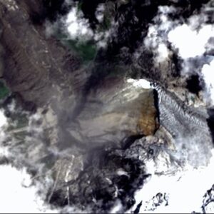
In a preliminary assessment shared following the disaster, Kaul said a shrinking and unstable glacier on the northwestern face of the Langtang Lirung massif appears to have supplied the ice avalanche that generated the destructive debris floods.
“A shrinking, unstable glacier (with a substantial detached terminal mass) on the NW face of the Langtang Lirung massif supplied the ice avalanche that seems to have generated the devastating debris floods along the Lhende-Bhotekoshi-Trishuli River,” Kaul said.
The Langtang Lirung massif rises to elevations of roughly 6,200 to 7,234 metres, while the suspected avalanche is believed to have descended rapidly from around 4,500 metres to approximately 3,000 metres along the Lhende river valley.
Massive Ice Collapse May Have Fuelled Debris Flow
According to Kaul, the volume of ice involved in the collapse could have been enormous.
“I know that glacier, and my guess is that the mass of ice that collapsed from its terminal section and all the dead ice nearby could have easily been 5 billion litres in volume,” he said.
He explained that the rapidly descending avalanche of pulverised and thawing ice would have picked up large quantities of rock debris and water-saturated morainic sediments.
This process, he said, could have transformed the initial ice avalanche into a highly destructive and much larger debris flow before it entered the sediment-rich waters of the Lhende River.
“The avalanche of pulverised, speedily thawing ice could have entrained a much larger volume of rock debris and monsoon-drenched morainic sediments, transforming into a monstrously kinetic debris flow far more voluminous than the original material,” Kaul said.
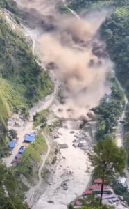
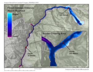
The scale of the flooding was dramatically illustrated by footage showing the Lhende debris flood engulfing infrastructure at Rasuwagadhi, the major Nepal-China border crossing.
Nepal-Tibet Flood Mystery: Satellite Images Point to Massive Glacier Collapse
Earthquake Report Was Initially Misleading
An initial report had attributed the event to an earthquake of magnitude 4.4. Kaul, however, said subsequent analysis of long-period seismic waves indicated that the seismic energy associated with the event was equivalent to a magnitude 5.2 earthquake and was generated by the glacier collapse, ice avalanche and resulting debris flow.
“The seismic energy had in fact been generated by the glacier collapse – ice avalanche – debris flow event. It was the consequence of the glacial event and not its cause,” Kaul said.
He compared the visual characteristics of the Nepal disaster with the February 2021 Ronti Gad-Rishi Ganga rock-and-ice avalanche disaster in Uttarakhand, India.
According to Kaul, the vertical scale of the debris flood at Rasuwagadhi was a particularly strong indicator of an avalanche-to-flood transformation.
“The vertical scale was a strong visual marker of that familiar avalanche-flood transformation, so one immediately suspected a glacier collapse,” he said.
Himalayan Glaciers Face Growing Instability
Kaul cautioned that the conditions observed around Langtang Lirung are not necessarily an isolated phenomenon.
“The shrinking, crumbling glaciers of Langtang Lirung that hang precariously over the now-ravaged valley of the Lhende are not exceptional,” he said.
He pointed to thermally destabilised upper catchments in other parts of the Himalayas, including the Suru River in western Ladakh and the Lachen Chu in northern Sikkim.
Kaul linked the growing risk to a combination of climatic and hydrological changes, including rising temperatures, higher freezing levels, declining winter snowfall and increasingly intense summer rainfall.
“The combination of rising temperatures (and freezing level altitudes), declining winter snowfall, and increasing extreme-intensity summer rainfall events is bound to generate very many more glacier-related floods in very many more parts of the Himalaya in the coming years,” he said.
The assessment remains preliminary and does not, by itself, establish the definitive cause of the August 26 floods. Detailed field investigations, satellite analysis, seismic data and glaciological studies will be required to conclusively determine the sequence and scale of the event.
Nepal Flood Disaster: What Planet Satellite Images Reveal About the Trigger
Follow The Raisina Hills on WhatsApp, Instagram, YouTube, Facebook, and LinkedIn




About The Author