By TRH World Desk
As Nepal’s death toll climbs past 700 with near-total transparency, China has confirmed a fraction of that number on its own side of the same catastrophe — and the footage of what actually happened in Tibet keeps disappearing from the Chinese internet almost as fast as it appears.
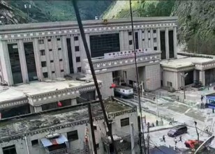
New Delhi, August 31, 2026 — A wall of water and debris nearly 30 feet high tore down from a Himalayan glacier collapse on August 27, obliterating the Gyirong Port border crossing between China’s Tibet Autonomous Region and Nepal’s Rasuwa district, and continuing downstream to devastate communities across northern Nepal. Four days later, the disaster stands as one of the deadliest floods in the region’s modern history — and one of the clearest recent illustrations of how differently China and its neighbours handle disclosure during a shared catastrophe.
The disaster originated with a sudden glacial collapse in the high mountains above Gyirong. NBC News reported Chinese state broadcaster CCTV described monitors showing just a seven-minute span between the initial avalanche and its impact on Gyirong Port, calling the event one that “struck suddenly, with a large peak flow, high speed, severe destructive force and a wide impact area.” ABC News reported that the U.S. Geological Survey had registered a 5.2-magnitude seismic event tied to the landslide — initially misreported as an earthquake — and that a Columbia University geophysicist told the outlet it appeared a large glacier, or significant portions of one, broke away from a cliff roughly 16,000 feet high before sliding some 6,000 feet down the slope.
The resulting surge of water, ice, and rock swept through Gyirong Port and continued downstream into Nepal’s Bhotekoshi and Trishuli river systems, destroying bridges, roads, hydropower infrastructure, and entire sections of riverside villages across both sides of the border.
Two Countries, Two Very Different Death Tolls
The scale of destruction has become clearer in Nepal largely because Nepali authorities have released detailed, regularly updated figures. The Star reported that as of Sunday, August 30, Nepal’s disaster authority had confirmed 734 deaths, with 2,498 people still missing and 7,514 rescued — figures that had already climbed from roughly 165 dead just days earlier, according to earlier reporting. NPR reported the death toll had surpassed 670 by Saturday, citing the Associated Press, with survivors describing losing entire families; one man told a reporter he had lost all nine members of his family in the flood.
China’s public figures for its own side of the border have moved far more slowly, and far more narrowly. ABC News reported that as of Friday, Chinese state news agency Xinhua had confirmed just seven deaths and 554 people missing in Tibet’s Gyirong County. The Star’s later reporting, citing a weekend press conference by Tibet officials, put the figure at 16 confirmed deaths and 546 missing as of Saturday evening — the first time Chinese authorities provided even a partial nationality breakdown of the missing, listing 261 foreign nationals from 23 countries, including 104 from Nepal, 49 from India, 33 from Latvia, 18 Americans, and 15 Britons.
That breakdown, however limited, was notable specifically because it was such a departure from the pattern up to that point. Al Jazeera reported that in the disaster’s earliest days, Chinese authorities in Gyirong County said only that they feared “major casualties,” without providing specifics — even as Nepal was already releasing detailed, region-by-region breakdowns of its own toll.
The starkest illustration of the information gap has been what happened to video of the disaster itself. The BBC reported that dramatic CCTV security-camera footage — showing a torrent of water tearing through Gyirong Port as hundreds of people ran for their lives — spread rapidly around the world after it first emerged, appearing on screens everywhere except inside China. The broadcaster reported that only a single still-frame image from that footage had been shown by China’s state-run flagship news bulletin, and that the full video became extremely difficult to find on China’s heavily censored internet, along with virtually any first-hand survivor accounts from the disaster zone.
Radio Free Asia reached a similar conclusion, citing Ryan Fioresi, executive director at a Washington-based advocacy organization, who described the Chinese government as “severely restricting” detailed information about the situation inside Tibet. RFA’s comparison of satellite imagery taken August 23 and August 27 showed customs buildings, a bridge, and other infrastructure along the border had been swept away — visual confirmation, independent of any Chinese government disclosure, of just how significant the destruction inside Tibet actually was.
Restricted Access, By Design
China’s information gap isn’t simply a byproduct of chaotic disaster response — it reflects an access regime that predates the flood entirely. CNN reported that China’s National Immigration Agency formally barred Chinese visitors from entering Shigatse’s border areas as the disaster unfolded, and noted that the region was already subject to tight, pre-existing restrictions: local travellers require permits to enter border zones including Shigatse and the Everest scenic area, foreign travellers need special permits to enter Tibet at all, and foreign journalists, diplomats, and academics face their own separate restrictions on movement in the region.
That structural opacity means even well-resourced international outlets have had no independent way to verify Chinese casualty figures, assess the true scale of destroyed infrastructure, or speak directly with survivors on the Tibetan side of the border — a sharp contrast with Nepal, where journalists, aid workers, and diplomats have had comparatively open access to affected areas.
Nepal Flood Crisis: Balen Shah Faces His Biggest Test Yet as India-China Challenge Looms
A New Hazard: The Dam That Formed by Accident
Compounding the disaster, the same landslide that triggered the initial flood also created a new and unstable hazard. The Star reported that debris from the Wednesday glacier collapse formed a natural dam across the Nepal-China border, creating a lake that began overflowing into rivers on the Nepali side by the weekend — prompting authorities to repeatedly suspend rescue operations amid fears that the makeshift dam could fail and trigger a second, potentially even more destructive flood. CNN separately reported the same landslide-formed lake was continuing to grow in China’s Gyirong County as of Thursday, with authorities warning of further landslides and flooding as additional rain moved through the region.
Where Chinese authorities have spoken publicly, the framing has consistently centered on climate change rather than any question of infrastructure, monitoring, or preparedness in the region. CCTV attributed the disaster to “glacier instability resulting from the long-term effects of climate warming,” while The Star reported Chinese officials have linked the broader disaster to climate change in public statements, and that Xi Jinping himself called for continued search efforts and improvements to disaster monitoring and early-warning systems.
That framing may well be scientifically accurate — the broader link between accelerated Tibetan Plateau warming and glacial instability is well documented. But it also has the effect of locating responsibility entirely in a diffuse, global phenomenon rather than in any specific regional infrastructure, monitoring, or transparency failure — a framing that has drawn little independent scrutiny given how limited outside access to the affected area remains.
What This Disaster Reveals
Beyond the immediate human toll, this disaster has become an unusually clear real-time case study in how China manages disclosure during a shared regional crisis. Nepal, with far fewer resources, has released granular, frequently updated casualty data, allowed extensive media access, and openly stated it may need $4 billion to $5 billion in reconstruction aid. China, by contrast, has offered infrequent, aggregated figures, actively restricted footage and journalist access, and maintained a permit-based control system over the affected border region that long predates this specific disaster.
For downstream communities and neighbouring governments — many of which depend on accurate, timely information about conditions on the Tibetan Plateau to manage their own flood risk, as previous reporting on Tibetan glacial melt and Chinese dam-building has highlighted — this pattern of restricted disclosure carries consequences well beyond this single flood. With rescue operations still underway, casualty figures still rising on both sides of the border, and the landslide-formed lake still threatening secondary flooding, the full scope of what happened inside Tibet may not be fully known for weeks, if it becomes fully known at all.
Nepal Flood Horror: 1,500-Ft Surge? New Terrain Analysis Reveals Shocking Scale
Follow The Raisina Hills on WhatsApp, Instagram, YouTube, Facebook, and LinkedIn