By TRH World Desk
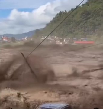
Wednesday’s flash flood that tore through Nepal’s Rasuwa district wasn’t a freak event. It was the latest expression of a slow-moving crisis building across the Tibetan Plateau — one that glacier science, dam engineering, and geopolitics are now colliding to make worse.
New Delhi, August 26, 2026 — When a sudden surge of water and debris crashed down the Bhotekoshi River into Nepal’s Rasuwa district on Wednesday, local officials called it “unprecedented.” But for scientists who study the Tibetan Plateau, the disaster fit an increasingly familiar pattern — one playing out with growing frequency across a region sometimes called the Third Pole, where nearly two billion people downstream depend on rivers whose sources are melting faster than expected, running through terrain that a rapidly expanding wave of Chinese infrastructure is making more dangerous, not less.
Is the Melt Actually Accelerating?
The short answer, according to the source material behind this week’s flood, is yes — and the pace is alarming glaciologists. The Japan Times, in a commentary on the broader crisis, described the Tibetan Plateau as home to vast glacial reserves amounting to the largest store of fresh water outside the Arctic and Antarctic, and noted the plateau feeds 10 major Asian river systems supplying water to nearly 20% of the world’s population.
What’s changed is the rate of loss. Nikkei Asia, in an opinion piece on China’s Himalayan dam ambitions, put the underlying climate dynamic starkly: Tibet is warming twice as fast as the global average, accelerating glacier melt and permafrost thaw, a process the piece noted has consequences reaching far beyond the region itself, since the plateau’s height and mass help shape monsoon patterns and atmospheric circulation across the Northern Hemisphere.
The basin at the center of the Nepal disaster has been a known hotspot for exactly this kind of risk. Peer-reviewed research on the Poiqu-Bhotekoshi and Gyirong-Trishuli transboundary basins — the same river systems spanning the China-Nepal border — has identified 28 glacial lakes highly susceptible to catastrophic outburst floods, with modelled worst-case scenarios capable of releasing peak discharges exceeding 38,000 cubic meters per second. The flash flood struck the same general river system that produced a similarly devastating flash flood in July 2025, and a 2016 debris flow that caused more than $70 million in damage to the same area — a pattern of recurrence, not a one-off.
Why Melting Glaciers Make Floods More Likely, Not Less
It’s a counterintuitive dynamic: melting glaciers don’t simply mean more water flowing downstream in a predictable, gradual way. As glaciers retreat, they leave behind expanding lakes dammed by loose glacial debris called moraines — inherently unstable barriers that can fail suddenly, releasing catastrophic volumes of water and sediment in minutes. These glacial lake outburst floods, or GLOFs, are becoming both more frequent and more severe as the underlying ice retreats faster.
The Japan Times’ broader assessment of the region frames this instability as part of a much larger emerging crisis, describing the unfolding situation as a slow-burning environmental calamity that is threatening the water security, ecological balance and geopolitical stability of the entire Asian continent.
How China’s Brahmaputra Card Risks India’s Northeastern Lifeline
China’s Infrastructure Boom: Compounding the Risk
This is where the second, more contested layer of the crisis comes in. Even as glacial retreat destabilizes the terrain, China has pursued one of the most ambitious dam-building campaigns in modern history across the same plateau — and critics say the pace and opacity of that construction is amplifying risks that climate change has already put in motion.
The Japan Times was direct in its criticism of the process, describing more than two decades of an aggressive and opaque dam-building spree, centered on — though not limited to — the Tibetan Plateau, while noting Beijing has refused to negotiate a water-sharing treaty with any downstream country, leaving those nations to absorb the consequences of decisions made entirely upstream.
The centerpiece of that campaign is the Yarlung Tsangpo hydropower project — set to become the world’s largest hydroelectric facility, tripling the capacity of China’s Three Gorges Dam. The South China Morning Post reported that the project, launched by Premier Li Qiang at a groundbreaking ceremony in Nyingchi, is located on a river that has raised concerns about water supply and environmental impact downstream in India and Bangladesh — concerns China’s own diplomats have had to publicly address. The Post separately reported that a senior Chinese diplomat in India, addressing the backlash, argued critics were wrong to frame the project as a “Chinese weapon,” insisting Beijing remained committed to a policy of building friendships and partnerships with its neighbours.
The project’s location is known to be in one of the world’s most seismically active zones. Experts have called China’s dam building decision decision “more than reckless” — warning that any structural failure, whether from an earthquake or reservoir-induced seismicity, would devastate India’s northeast and Bangladesh, putting tens of millions of people at risk.
The Specific Mechanism: Glaciers Feeding Unstable Dam Sites
The connection between glacial melt and dam risk isn’t abstract — it’s structural. Research cited in coverage of China’s Tibetan hydropower push notes that accelerated warming is simultaneously melting glaciers, destabilizing seasonal river flows, and increasing sedimentation risks inside dam reservoirs themselves, while aerosol deposits in the region further amplify glacial retreat — a feedback loop that compounds risk for both the infrastructure and the populations living downstream of it.
That compounding effect has already produced real damage. A landslide-triggered debris flow originating from a Tibetan glacial lake in 2016 struck the Upper Bhotekoshi hydropower plant directly, destroying infrastructure and damaging the Arniko Highway — a preview, researchers say, of the kind of cascading failure that becomes more likely as the pace of glacial retreat increases and dam construction proceeds without fully accounting for that risk.
A Region With No Water-Sharing Framework
Perhaps the starkest structural problem underlying this entire crisis is institutional, not physical: there is no binding, comprehensive water-sharing treaty governing the rivers flowing out of Tibet into South and Southeast Asia. The absence of any negotiated framework leaves downstream countries — Nepal, India, Bangladesh, and others — with essentially no formal mechanism to influence, monitor, or seek recourse over decisions made far upstream, whether those decisions involve dam construction, water release timing, or infrastructure sited on demonstrably unstable ground.
That gap matters enormously for a country like Nepal, which sits directly beneath some of the most active glacial and geological hazard zones on the plateau, with essentially no ability to independently monitor conditions on the Tibetan side of the border before a flood like Wednesday’s reaches Nepali territory.
What This Means Going Forward
None of this means every future flood in Nepal, India, or Bangladesh will trace directly back to Chinese dam construction — Wednesday’s Bhotekoshi flood, for instance, has not yet been officially attributed to any specific cause, glacial or otherwise, by Nepali authorities. But the broader pattern described across this reporting is consistent and concerning: an accelerating rate of glacial retreat, a documented rise in the frequency of glacial lake outburst floods specifically in the China-Nepal border region, a major unregulated dam-building campaign proceeding in some of the same at-risk terrain, and no water-sharing governance structure to manage any of it collectively.
For downstream nations like Nepal — geographically small, economically limited, and directly beneath the most volatile stretches of this system — the practical challenge isn’t proving any single flood’s cause. It’s building monitoring, early-warning, and resilient infrastructure fast enough to keep pace with a physical system that is changing faster than the region’s diplomacy or engineering standards currently account for.
“The Flood Is Unprecedented and Huge”: Nepal Scrambles as Bhotekoshi Flash Flood Devastates Rasuwa
Follow The Raisina Hills on WhatsApp, Instagram, YouTube, Facebook, and LinkedIn