Science Desk | May 31, 2026
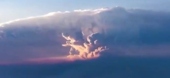
Pyrocumulonimbus clouds inject wildfire smoke into the stratosphere, alter weather, and are growing more frequent. Scientists say the world still isn’t ready.
Heard of cumulonimbus? No! The brooding towers of cloud. They roll in at the end of a summer afternoon. Heralding thunder and heavy rains.
Have you encountered the term pyrocumulonimbus? Yes! You must have. As wildfires grow in ferocity across every inhabited continent, the term is becoming familiar.
Only the other day, on May 30, the people in the Churu district of Rajasthan in India got a glimpse of what it feels like to look into the eye of an apocalypse. Waves of sandstorms as high as high rises swept through the district.
Writing in the June 2026 issue of BBC Science Focus Magazine, journalist Bill McGuire sets out the stakes with urgent clarity: “The term pyrocumulonimbus — and its abbreviation PyroCb — has only been in use since 2004, but we can be certain that these dangerous storm clouds have been around forever. They build wherever enormous quantities of heat energy are pumped into the air over a relatively short period of time.” McGuire, whose feature is headlined “Mega-firestorms are erupting around the globe. We are not prepared,” argues these phenomena should not be treated as novel but as an accelerating ancient danger — one pushed higher and harder by human-caused global heating.
With the unveiling of the second term of US President Donald Trump, climate change discourse has become muted. Trump claims that all talks of climate change are bogus.
The science backs up the claims of mcGuire. Pyrocumulonimbus clouds are fire-induced thunderstorms. They are capable of lofting smoke, soot and aerosols far into the stratosphere. That could be five to seven miles above Earth’s surface. There they hold out for months. They affect climate on a planetary scale.
Dave Peterson is a meteorologist at the US Naval Research Laboratory. He described their reach as rivalling or exceeding the atmospheric impact of the majority of volcanic eruptions observed over the last decade. During Australia’s catastrophic Black Summer of 2019–2020, a pyroCb “super outbreak” over 51 hours produced 38 separate updraft pulses, more than half of which injected smoke directly into the stratosphere.
The danger is not just fires. David Peterson has described pyroCbs as “giant chimneys, funnelling smoke that’s being released by the fire up into a thunderstorm”. They are “extremely dirty thunderstorms.” Smoke particles help water to condense on. Once aloft, that smoke generates its own stratospheric weather system. It absorbs solar energy. And then it continues to rise for weeks after the original fire has been extinguished.
Researchers at the University of New South Wales have issued stern warning. Episodes are now regular. Fire-generated thunderstorms, practically unheard of a few decades ago, are more common now. And climate models point to more dangerous conditions. Because greenhouse gas emissions continue to rise. That Paris Accord and other commitments to stop emissions have largely been abandoned add to the rising calamities.
Climate scientists have already flagged 2026 as potentially one of the worst wildfire years ever recorded. Major blazes are burning across Africa, South America and the northern hemisphere simultaneously. In India, the Himalayas in the month of May witnessed mountain fires raging for weeks.
They set the backdrop to McGuire’s warning. These storm clouds represent “an old threat that’s been growing bigger, stronger and more dangerous the whole-time human activities have been pushing up the planet’s temperature.” No more an alarm. But a fact of data now. The window for complacency, if it ever existed, has burned shut.
FAQ:
Q: What is a pyrocumulonimbus cloud?
A: A pyrocumulonimbus (pyroCb) is a massive storm cloud generated by the extreme heat of a wildfire. It can drive lightning, fire tornadoes, and dangerous wind shifts — and inject smoke into the stratosphere where it can affect global climate for months.
Q: How long has the term pyrocumulonimbus been in use?
A: The term has only been in scientific use since 2004, though the phenomenon itself has existed throughout human history and is growing more frequent and severe as global temperatures rise.
Q: Are pyrocumulonimbus clouds getting more common?
A: Yes. Scientists at the University of New South Wales and elsewhere warn that fire-generated thunderstorms are becoming more frequent, driven by hotter, drier conditions linked to accelerating climate change.
California Wildfire Rages in Melting Climate Crisis Cauldron
Follow The Raisina Hills on WhatsApp, Instagram, YouTube, Facebook, and LinkedIn